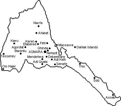
The Geography and Location of Eritrea
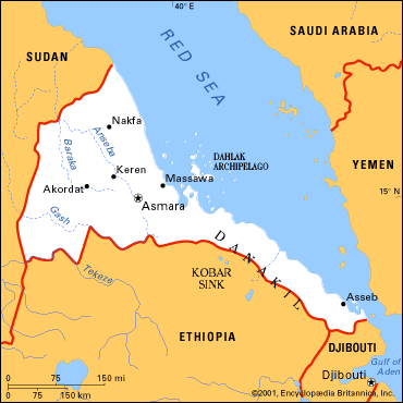
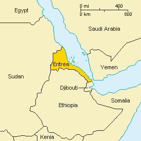
Eritrea is located in North East Africa (between 12° and 18° north, and 36° and 44° east) and includes the Dahlak Archipelago and other islands along the Red Sea coast. It is bordered by Sudan to the north and west, Ethiopia to the south, Djibouti to the south-east and the Red Sea to the north and north-east.
With a land area of about 125.000 km2, Eritrea is about the size of England, or the state of Pennsylvania in the USA. The coastline measures around 1.200 km and off it there are over 350 islands, of which 210 comprise the area of the Dahlak Archipelago.Sea floor spreading occurs in the Red Sea, creating new land, and in the Afar triangle, only one of the two places on earth were it occurs on dry land (the other being Iceland). Many of the mountains in Eritrea are remnants of when Africa was joined to the Arabian peninsula, millions of years ago.
Eritrea was known at times as Mareb Mellash ("This side of the Mareb River") or Bahrmeder ("Sealand"). The name "Eritrea" is of foreign origin and has been attributed to a derivative of the ancient Greek cartographic designation, Mare Erythrean ("Red Sea"), fragment 67 of Aeschylus:There the sacred waters of the Erythrean Sea break upon a bright red strand, and at no great distance from the ocean lies a copper-tinted lake - the lake that is the jewel of Ethiopia - where the all-pervading sun returns again and again to plunge his immortal form, and finds solace for his weary round in gentle ripples that are but warm caress.It was not until the arrival of the Italians in the 19th century however that the country was officially called Eritrea.
Eritrea looks like a funnel; wide in the northwest and tapering to a narrow strip in the south-east. Topographically, the country consists of three regions:
The major rivers in Eritrea are the Anseba and Barka river flowing north; the Gash and Tekeze rivers on the border with Ethiopia flowing west into Sudan. The upper course of the Gash river is known as the Mereb river. These rivers are not year round rivers. They do not run on a regular basis, but fed by seasonal rains called azmera and kremti.
- The first region is a narrow eastern lowland desert strip along the Red Sea coast that accounts for around 33% of the land area coast. The land in this area is mostly infertile due to the high salt content and a year round average temperature of 25 Celsius.
- The second region is the northern extension of the Ethiopian Plateau in the north-central region which is dissected by the valleys of westward flowing rivers, which runs Eritrea's border with Ethiopia. This area is the most fertile area of the country, receiving up to 900 mm of rain per year; the area has been the site of the war between Eritrea and Ethiopia for 40 years. Elevation of up to 3000 meters above sea level makes the climate more moderate in this area than in the coastal region.
- The third geographical region is the western plains, which occupy the vast area extending to Eritrea's western border with Sudan. This is the most arid area in the country, receiving only 200 mm of rain per year.
The highest point is the mountain called Emba Soira (9,880 feet or 3,010 meter). The lowest point is the Kobar Sink in the Danakil Depression (380 feet or 116 meter below sea level).
Eritrea is three hours ahead of GMT. There is a two hour time difference between continental Europe and Eritrea, except when Europe is on Summer time. Then the difference is only one hour (ahead). There is an eight hour time difference (ahead) between USA Eastern Standard Time and Eritrea, which is reduced to seven during Daylight Savings Time.
Land boundaries 1,630 km Djibouti 113 km Ethiopia 912 km Sudan 605 km Coastline 1,200 km Land + island coastline 2,234 km
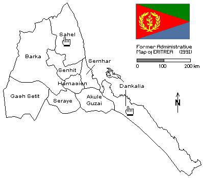
Eritrea - regions and provinces
immediately after the EPLF took over Eritrea, ten provinces were established - based on the eight regions existing under the Italian administrative model, but with Gash Setit separated from Barka and Asmara split from Hamasien.
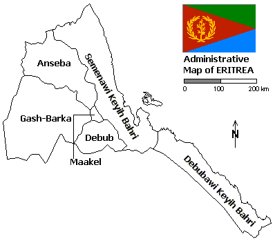
On April 15th 1996, Eritrea's ten colonial-era provinces were consolidated into six new regions (zobas) and regional administrative levels were cut from four to three.
Former administrative regions (until 1995) Province Capital Est. pop. (city) Akule Guzai Adi Qayeh (Adekeieh) 23,000 Asmara (Asmera) Asmara (Asmera) 500,600 Barka Agordat (Akordat) 25,000 Denkalia Assab (Asseb) 21,300 Gash Setit Barentu 16,200 Hamasien Asmara (Asmera) 500,600 Sahel Nacfa (Nakfa) 25.000 Semhar Massawa (Mitsiwa) 23,100 Senhit Keren (Cheren) 74,800 Seraye Mendefera (Adi Ugri) 17,500
Current administrative regions (since 15-04-1996) Province Capital Surface km2 Est. pop. (city) Gash-Barka Agordat (Akordat) 33,200 25,000 Debubawi Kayih Bahri Assab (Asseb) 27,600 21,300 Maakel Asmara (Asmera) 1,300 500,600 Semenani Kayih Bahri Massawa (Mitsiwa) 27,800 23,100 Anseba Keren (Cheren) 23,200 74,800 Debub Adi Ugri (Mendefera) 8,000 25,800 Total Eritrea Asmara (Asmera) 121,100 500,600 2002 Population data: Ministry of local Government Eritrea The provinces Semenawi Keyih Bahri and Debubawi Keyih Bahri
are also known as the Northern Red Sea Zone and Southern Red
Sea Zone, where the Maakel region is also known as Central Zone.Eritrea - major towns
| Place | Administrative region | Variants of the name | Elevation | Position | ||
| meter | feet | |||||
| Adi Keih | Debub | Adi Keyh, Adi Qayeh, Adi Kai, Adi Kaiih, Addi Caieh, Addicaie, Âddî K'eyih | 2420 | 7942 | 14 51 N | 39 22 E |
| Adi Qala | Debub | Adi Quala, Adi Kuala, Adi Kwala, Adi Qala | 2053 | 6738 | 14 38 N | 39 50 E |
| Agordat | Gash Barka | Akurdet, Ak'ordat | 637 | 2093 | 15 32 N | 37 53 E |
| Assab | Southern Red Sea Zone | Assab, Asseb, Aseb, Asab | 0 | 0 | 13 00 N | 42 44 E |
| Asmara | Maakel | Asmera | 2363 | 7755 | 15 20 N | 38 56 E |
| Barentu | Gash Barka | 994 | 3264 | 15 07 N | 37 36 E | |
| Beilul | Southern Red Sea Zone | Beylul, Bêylul | 13 | 45 | 13 16 N | 42 20 E |
| Dekemhare | Debub | Dek'emhare, Decamere, Dekemehare, Decamhare, Dek'emhâre | 1979 | 6496 | 15 04 N | 39 03 E |
| Ghinda | Northern Red Sea Zone | Ghinda'e, Ginda, Gînda | 1246 | 4091 | 15 27 N | 39 03 E |
| Hirgigo | Northern Red Sea Zone | Hargigo, Harkiko, Arkiko, Archico | 6 | 22 | 15 32 N | 39 27 E |
| Iddi | Southern Red Sea Zone | Idi, Ed, Edd, Êdd | 8 | 29 | 13 56 N | 41 41 E |
| Keren | Anseba | Cheren, Kheren | 1401 | 4599 | 15 47 N | 38 28 E |
| Mendefera | Debub | Adi Ugri, Âddî Ugrî | 1986 | 6519 | 14 53 N | 38 49 E |
| Mersa Fatma | Northen Red Sea Zone | Mersa Fatuma | 1 | 6 | 14 54 N | 40 18 E |
| Massawa | Northern Red Sea Zone | Mits'iwa'e, Massoua, Massaua, Mesewa, Massowa, Mits'iwa | 0 | 0 | 15 37 N | 39 29 E |
| Nacfa | Northern Red Sea Zone | Nakfa, Nac'fa, Nak'fa | 1556 | 5108 | 16 40 N | 38 29 E |
| Nefasit | Northern Red Sea Zone | 1991 | 6535 | 15 20 N | 39 04 E | |
| Om Hager | Gash Barka | Om Hajer, Umm Hajar, Om Hajer, Om Ager | 599 | 1968 | 14 20 N | 36 39 E |
| Senafe | Debub | Sen'afe | 2364 | 7759 | 14 41 N | 39 25 E |
| Tessenei | Gash Barka | Teseney | 584 | 1919 | 15 08 N | 36 40 E |
| Thio | Southern Red Sea Zone | T'i'o, Tiio, Tiyo | 0 | 0 | 14 42 N | 40 58 E |
| Zula | Northern Red Sea Zone | 22 | 75 | 15 15 N | 39 40 E | |
Regions and districts
Main articles: Regions of Eritrea and Districts of Eritrea


Eritrea is divided into six regions(zobas) and subdivided intodistricts (sub-zobas). The geographical extent of the regions is based on their respective hydrological properties. This a dual intent on the part of the Eritrean government: to provide each administration with sufficient control over its agricultural capacity, and to eliminate historical intra-regional conflicts.
The regions, followed by the sub-region, are:
The regions, followed by the sub-region, are:
| No. | Region (ዞባ) | Sub-region (ንኡስ ዞባ) |
|---|---|---|
| 1 | Maekel (ዞባ ማእከል) | Berikh, Ghala-Nefhi, Semienawi Mibraq, Serejaka, Debubawi Mibraq, Semienawi Mi'erab, Debubawi Mi'erab, Asmara |
| 2 | Anseba (ዞባ ዓንሰባ) | Adi Tekelezan, Asmat, Elabered, Geleb, Hagaz, Halhal, Habero, Keren, Kerkebet, Sel'a |
| 3 | Gash-Barka (ዞባ ጋሽ ባርካ) | Agordat, Barentu, Dghe, Forto, Gogne, Haykota, Logo-Anseba (Adi Neamen Awreja), Mensura, Mogolo, Molki, Guluj, Shambuko, Tesseney, La'elay Gash |
| 4 | Debub (ዞባ ደቡብ) | Adi Keyh, Adi Quala, Areza, Debarwa, Dekemhare, Mai Ayni, Mai Mne, Mendefera, Segeneiti,Senafe, Tserona |
| 5 | Northern Red Sea (ዞባ ሰሜናዊ ቀይሕ ባሕሪ) | Afabet, Dahlak, Ghel'alo, Foro, Ghinda, Karura, Massawa, Nakfa, She'eb |
| 6 | Southern Red Sea (ዞባ ደቡባዊ ቀይሕ ባሕሪ) | Are'eta, Central Dankalia, Southern Dankalia, Assab |
Eritrea - routes and distances
| Asmara - Adi Quala | |||
| Adi Guadad | 12 km | Adi Akelas | 71 km |
| Selae Da'ero | 19 km | Ahmni Haili | 76 km |
| Sheketi | 27 km | Shega Ayamo | 81 km |
| Debarwa (Dbarwa / Debarua) | 36 km | Denghwelo | 85 km |
| Halhal (Halhale) | 39 km | Adelgese | 88 km |
| Tera Emni (Teramni) | 46 km | Adi Quala (Adi Qala / Adi Kwala) | 92 km |
| Guala | 48 km | Enda Gherghis | 109 km |
| Shega Wedi Bisrat | 51 km | Ksad Ika | 116 km |
| Mendefera (Adi Ugri) | 60 km | Mereb (Ethiopian border) | 121 km |
| Asmara - Mensura | |||
| Kushet | 8 km | Ila Golma (Ela Golma) | 58 km |
| Tsa'edakristyan | 11 km | Embed Bekeli | 63 km |
| Tse'azega | 17 km | Mai Medef (Mai Medaf) | 67 km |
| Adi Gheberu (Adi Gebru) | 21 km | Arha Go'ul (Arha Gu'ul) | 77 km |
| Adi Warhiseb (Adi Worhiseb) | 29 km | Ghergher Wedi Chirwa | 80 km |
| Mekarka (Mekerka) | 32 km | Inter Ghergher | 84 km |
| Deki Shehaye | 37 km | Sherf Megawida | 94 km |
| Melat Zanoy | 46 km | Mensura | 106 km |
| Denagul | 54 km | ||
| Asmara - Senafe | |||
| Adi Hawesha | 14 km | Endehush | 88 km |
| Zegeb (Zegub) | 17 km | Adi Kuta | 94 km |
| Waekerti | 30 km | Aba Selam | 100 km |
| Awlih Tseru | 33 km | Ruba Adi Uwegra | 105 km |
| Dekemhare (Decemhare / Decamere) | 40 km | Adi Keyh (Adi Kaieh / Adi Keih) | 111 km |
| Afelba | 50 km | Tekonda | 114 km |
| Degra | 53 km | Minak (Menak) | 117 km |
| Ma'ereba | 56 km | Keskes | 128 km |
| Segeneti (Seganeti / Segeneiti) | 62 km | Akeb Tarig | 130 km |
| Degra Lebe'a | 67 km | Senafe | 135 km |
| Digusa | 71 km | Dubdub | 142 km |
| Adi Hadid | 76 km | Kisat Bruch | 149 km |
| Mai Seraw | 78 km | Mai Tsehada | 154 km |
| Mendefera - Adi Bahailai | |||
| Adi Aklas | 12 km | Emba Merach | 26 km |
| Imni Haili | 16 km | Turke | 32 km |
| Durko (Dirko) | 19 km | Kudo Abutsur | 36 km |
| Adi Herwa (Adi Hurwa) | 28 km | Adi Bahailai | 42 km |
| Mendefera - Qinafna | |||
| Kudo Felasi | 4 km | Emba Gelay | 21 km |
| Deranto | 10 km | Endaba Shiuk | 26 km |
| Debri | 15 km | Qinafna | 36 km |
| Asmara - Tessenei | |||
| Adi Abeito | 5 km | Keren (Cheren) | 91 km |
| Emba Derho (Embaderho) | 12 km | Tenkulahaz | 97 km |
| Mai Menka | 18 km | Gordu | 106 km |
| Serejeka | 22 km | Humed | 109 km |
| Shima Negus | 23 km | Hagaz | 116 km |
| Ade Kolem | 25 km | Aderde | 132 km |
| Geshinashum | 29 km | Ingerne | 154 km |
| Dekemhare Dembesan | 35 km | Agordat (Akurdet / Akordat) | 172 km |
| Adi Teklezan | 39 km | Mogolo | 202 km |
| Adi Keretz | 47 km | Barentu | 237 km |
| Shindua | 52 km | Adi Keshi | 268 km |
| Habrengaqha | 58 km | Gonjeh | 272 km |
| Balua | 61 km | Haykota (Haicota) | 307 km |
| Adi Berbere | 64 km | Tessenei (Teseney / Tessenai) | 357 km |
| Elabered (Elabored) | 68 km | Adi Gedur | 366 km |
| Ruba Anseba | 75 km | Telaka Asher | 387 km |
| Halib Mentel | 80 km | Kassala | 425 km |
| Derkok | 83 km | ||
| Asmara - Nacfa | |||
| Keren (Cheren) | 91 km | Gezgeza (Gz'Gza) | 124 km |
| Humel Malo | 106 km | Afabet | 157 km |
| Genfelam | 114 km | Nacfa (Nakfa) | 227 km |
| Asmara - Solomona | |||
| Serejeka (Meleh) | 21 km | Sabur | 54 km |
| Afdew | 23 km | Fatjoi | 60 km |
| Kondoba | 28 km | Medhanid | 61 km |
| Dekeseb | 31 km | Merama | 66 km |
| Zagr (Zager) | 33 km | Filfil (Fil Fil) | 68 km |
| Weki | 34 km | Wina | 75 km |
| Adi Anagole | 38 km | Solomona | 100 km |
| Assab - Kombelcha | |||
| Giwodo | 25 km | Tendaho | 300 km |
| Banda | 100 km | Mili | 330 km |
| Kantonera | 150 km | Ela Wuha | 360 km |
| Elida | 160 km | Bahti | 440 km |
| Baradiso | 185 km | Kombelcha | 465 km |
| Sardo | 200 km | ||
| Asmara - Zagr | |||
| Akria | 3 km | Zidishega | 27 km |
| Adi Nefas | 9 km | Azen | 28 km |
| Beleza | 11 km | Defere | 33 km |
| Anza | 16 km | Zagr (Zager) | 35 km |
| Quazen | 23 km | ||
| Agordat - Sawa | |||
| Igber Mana | 15 km | Rubabar | 70 km |
| Shegelet | 30 km | Yimel | 85 km |
| Shatara | 50 km | Khieru (Gheru) | 100 km |
| Mogo Rayb | 70 km | Sawa (Saua) | 130 km |
| Tessenei - Um Hajer | |||
| Kurumdut | 20 km | Hilat | 95 km |
| Kerset | 30 km | Um Hajer (Omhajer / Om Hager) | 114 km |
| Guluj (Golluig) | 45 km | Humora | 124 km |
| Asmara - Leban | |||
| Adi Rassi | 18 km | Mereb | 26 km |
| Kutmo Awlih | 21 km | Himbirti | 34 km |
| Abarda / Mai Nefhi | 25 km | Leban (Liban) | 44 km |
| Asmara - Sula'ahefera | |||
| Debarwa (Dbarwa / Debarua) | 36 km | Adi Kune'el | 47 km |
| Halhale | 39 km | Dekutsena | 56 km |
| Adi Gheda | 42 km | Adi Nahabay | 58 km |
| Adi Beshannes | 44 km | Adi Felesti | 64 km |
| Amadir | 55 km | Sula'afera | 72 km |
| Dekemhare - Mendefera | |||
| Querbarya | 12 km | Adi Rassi | 21 km |
| Adi Ghena | 17 km | Tera Emni (Teramni) | 29 km |
| Adi Nefas | 18 km | Mendefera (Adi Ugri) | 44 km |
| Dekemhare - Tsorona | |||
| Mai Edaga | 11 km | Hadish Adi | 43 km |
| Gura'e | 15 km | Kelai Ba'altet | 48 km |
| Adi Nebri | 25 km | Atira | 56 km |
| Gheniseba | 37 km | Tsorona | 66 km |
| Mai Aini (Mai Aine) | 38 km | ||
| Dekemhare - Nefasit | |||
| Keyh Kor | 7 km | Bazit | 23 km |
| Selah | 10 km | Mai Habar | 35 km |
| Gadien | 17 km | Nefasit / Debre Bizen | 47 km |
| Mendefera - Molki | |||
| Awi Adi | 10 km | Adi Gordi | 36 km |
| Adi Gurotto | 21 km | Areza (Arezza) | 42 km |
| Adeba Abdu | 27 km | Mai Dima | 60 km |
| Hatzina | 30 km | Molki | 92 km |
| Deka Worasi | 34 km | ||
| Asmara - Assab | |||
| Shegerni | 8 km | Zula | 174 km |
| Arberebou | 11 km | Irafayle | 194 km |
| Nefasit / Debre Bizen | 25 km | Ila Asa | 206 km |
| Embatkala (Imbat Kalla / Embatcala) | 37 km | Ruba Dale | 210 km |
| Ghinda | 48 km | Bordele | 225 km |
| Dongolo (Dongollo) | 52 km | Ghela'elo (Galelo) | 244 km |
| Dongolo Tahtay | 59 km | Akilo | 253 km |
| Gahtielay( Gahtelay / Ghatelai) | 73 km | Burai | 260 km |
| Mai Atal | 85 km | Mersa Fatuma (Mersa Fatma) | 275 km |
| Dogali | 94 km | Garsai | 289 km |
| Hitibelew | 108 km | Goro'roha | 323 km |
| Mitsua (Massawa) | 115 km | Tio (Thio) | 363 km |
| Hirghigo (Hirgigo) | 130 km | Idi (Iddi / Edi) | 483 km |
| Lahzin | 141 km | Bera'esoli | 553 km |
| Wi'a | 155 km | Beylul (Beilul) | 613 km |
| Foro (Forro) | 169 km | Assab (Asseb / Aseb / Asab) | 673 km |
No comments:
Post a Comment